Wild Rupshu
Wild Rupshu
trek

Duration
20 Days
Difficulty
Rigorous
Type
Trekking
Gear
Provided
ITINERARY
- Location : Ladakh
- Best Time to Visit : Mid June – September
- Terrain: High-Altitude Desert, Grasslands, Lakes, River Valleys, and Mountain Passes.
- Nearest Airports : Leh (Kushok Bakula Rimpochee Airport)
- Languages Spoken : Hindi
Our Overview
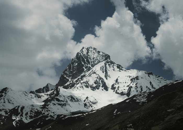
The vast Central Asian grassland, birthplace of Genghis Khan and the Mongols, stretches almost continuously from the rolling steppes of Mongolia, into the high Tibetan plateau and then south into north-west India. The Indian grassland is known as the Rupshu. As in Mongolia and Tibet, it is the home of nomadic Buddhist herders: the Changpas, Kharnakpas and Korzokpas. These nomads migrate between winter and summer pastures with their yaks, sheep and pashmina goats.
Their land is unremittingly high but varied: treeless plains, huge snow-covered mountains, high passes, turquoise lakes and grassy valleys cut by clear, glacier-melt rivers. Dr Chris Curry, Steve Amstutz and Geoff Bartram, veterans of hundreds of Himalayan treks and climbs, wrote to Indian Himalayan Excursions after their 2010 Rupshu crossing: “(it was) as amazing a trek as we have done. It is difficult to find such beauty, variety and remoteness with so few trekkers in the Himalaya these days. The wildlife was exceptional: Tibetan blue sheep, marmot, pika, hare and wild ass (kyang) in large numbers as well as wolf, black-necked cranes, bar-headed geese and our first sighting of snow leopard. And we trekked with Changpa horseman and spent wonderful times with their families. It was a truly memorable month.”
The trek begins from Rumtse, a Village at the foot of the 5368m high Tanglang Pass. Initially, the terrain is wide and relatively green, especially in July and Aug. The trail towards Tsokar winds over Kyumur La (4870m), Mandalchan La (4996m), and Shibuk La (5016m). The terrain gets narrow towards Tsokar Lake, once the major source of salt for Ladakh and now world-renowned for wader birds. Finally, we reach Tsokar Lake with Thugje monastery far on the other side and Nuruchan (a place with few houses, occasionally used by Changpas), on the right side.
Tso Kar Lake is the ‘salt lake’ of Rupshu, previously the site of large salt excavations by the Rupshu-pa nomads, a section of the lake given to each group each year when the salt trade between Tibet and the lower hills was thriving (after the border with China was closed in 1959). Today, Tso Kar Lake is not as salty as it previously was, and the salt trade has diminished in importance because of the introduction of iodized and subsidized Indian salt.
From the top of the next (and highest) pass, Yalung Nyo La (5440 m), we gain our first view of Tso Moriri, another magnificent high-altitude lake. Further trek down to the south of Tsomoriri, then enter the isolated Phirtse phu Valley to the right of Tsomoriri. This trek provides an opportunity to spot some rare Himalayan Wildlife. We end by trekking over Telakonla Pass and finishing in Pang.
Arrival at Delhi and Transfer to Hotel. Option of sightseeing around Delhi in the afternoon.
Transfer to Airport for Delhi - Leh Flight. Arrival at Leh, acclimatisation and exploring around. Overnight Hotel in Leh.
Acclimatisation and Monastery sightseeing. Overnight at a Hotel in Leh.
Drive up to Khardung La (5602m /18380ft):
The world’s highest motorable pass (39 km). This Drive takes one over one of the highest motorable roads across Khardung La (5,600 m) into spectacular deep, sheer-sided valleys, massive glaciers and high mountains such as Saser Kangri (7670 m). Return to Leh. Overnight in a Hotel.
Drive to Rumtse (2 hours). Trek from Rumtse to Kyama (4050m):
The first day of the trek. An easy trail leads to a beautiful campsite close to a spring.
Kyamar to Tisaling (4200 m), over Kumarla and Mandachandla (6-7 hours):
An early start is advised as it will be a long day. The trail goes up following the river, and gradually ascends to Kumur la (4900m). From here, enjoy the spectacular view of the Chang-Thang range. Then, steadily descend to the river bank, cross the river, and again ascend to the next pass, Mandachand la. From now is an easy descent toward the campsite on the pasture land of Tisaling.
Tisaling to Tsokar (4267 m) via Shibuk over Shibukla (4980 m) (6-7 hours):
2 hours trek till the pass, again spectacular view of the surrounding Himalaya, descend to Shibuk, where Himalayan marmots can be seen playing hide and seek. From here, there is an easy flat track on the large valley to the nomad headquarters at Tukche. Tukche is a small Tibetan village to the north of the lake. Most of its inhabitants are semi-nomadic Tibetan people who spend the winters in their villages at the lake.
On arrival in Tukche, establish the camp, and later visit the village and the old gompa (monastery) perched high on the top of the village. Stroll on the shores of Tsokar Lake to watch the birds and the lake changing its colour frequently while the sun is setting. This area is famous for the important fauna, such as Brahaminy duck, Brown headed gull, Great-crested Grebe, black necked Grebe, Bar-headed Geese, Black Necked Crane, Yellow-headed Wagtail, Pied Wagtail, Desert Wheatears, Raven, and Horned Lark.
Tsokar – Nuruchen (4650 m) (5 hours):
Today is an easy trek along Tsokar Lake upon a vast open plateau as far as Nuruchan. Pass Nuruchan village and continue along the stream for a few minutes to the campsite across the meadows. Overnight at a beautiful campsite near a small river. (4690m). Possibility of exploring the Valley to the right side or the left of the stream, widely extended plains do have many herds of Kyangs (Tibetan wild ass) grazing.
Nuruchen – Rachung Karu (4950 m) over Horlamkongka-la (4910m) (4 ½ Hours):
The day begins with a gentle ascent to the top of Horlamla pass (4900 m). From this vantage point, enjoy a magnificent view of the surrounding mountains and enchanting landscape with Tsokar Lake. The descent after crossing the pass is easy and gentle till the riverbed.
Continue upstream along the river till Rajung Karu. You find many Nomadic camps with their animals grazing across the meadows. In the afternoon, you may choose to interact with the nomads by visiting their camps and learning more about their way of life. You will find many yaks, sheep, and Pashmina Goats. Overnight at camp across beautiful meadows.
Note : There is a beautiful trail not much in use, to the right side along the stream, which forms a loop to join the trail on the other side of the pass.
Rachungkaru (4950m) – Kyamayuri La (5590m) – Kartse-la (5380m) – Gyama (5080m) (6Hours):
From the camp, walk through the nomadic camp and cross a small stream before gradually ascending the Kyamayuri-la pass (5300m). At the prayer flags at the top of the pass we finally get a view of Tso Kar Lake below us, and the trail leading to the other side of the Valley down to the wide open Tibetan plateau.
Descend into the valley to Gyamabarma with marmots and pikas popping their heads out of their holes to see who is passing, walking through herds of wild-looking yaks and dri (female yaks) with their young frolicking by their sides. We cross another small pass Kartse-la (5000m), and follow a winding, crystal clear stream from the valley floor for most of the way to the camp at Gyama, another nomadic camp. Overnight at camp (5080m).
Note: From Gyamabarma, instead of crossing the Pass (Kartse La), there is another option of following the crystal stream straight in the Valley, then turn right at the end of the ridge as the valley widens and continue following the stream to camp at Gyama.
Gyama – Korzok (4630m) over Yarlung Nyau La (5440m) (7 hours):
After breakfast, continue the trek to Korzok. An easy and gentle ascent right from the campsite to the top of Yarlung Nyau La (5440m). The ascent is beautiful, past grazing areas and through grassy, narrow valleys and towards the end, a slate-slab river, which we'll need to cross a few times. From here, observe the scenic beauty of Lake Tsomoriri and the Tibetan plateau, and to the south of the pass are the Mentok (flower) Peaks.
A steep and easy descent as far as summer pastureland (Korzok Phu), where you find more nomadic camps. You still have more than 30 minutes of trek from here, past the Korzok phu and continue along the small river flowing downstream as far as Korzok village. Arrive at the campsite. When you have recovered, you may visit the Korzok Monastery and enjoy a short hike around the many-hued Tsomoriri Lake. Overnight at campsite (4620m).
Korzok – Kyangdom (4550 m) (8 hours):
We'll leave our lovely camp early as it's a long, hot trek along the west of Lake Tso Moriri to our camp at Kyangdom, the southern edge of the Tsomoriri Lake. It's a wonderful day of walking along smooth rocks reflecting in the river, watching the bar-headed geese, up and over hills where you get views of the clouds and snow-peaks to the west, mirrored in the lake, next to sandy beaches. Water is scarce during this trek, so be prepared. The camp is beside the wetlands of Tsomoriri and is home to rare species of birds such as black-necked cranes and bar-headed geese. Camp at Kyangdom.
Kyangdom to Kun Motchey (4580 m) (5 hours):
The trail goes upward of the river from the south of the lake in the eastern direction. Twice easy river crossing, in the beginning the valley of Phertse Phoo is very narrow with colourful rugged rocks, and then slowly starts to open up to wide green meadows appear. The remoteness of this beautiful valley provides a good opportunity of spotting some rare Himalayan wildlife, including the elusive snow leopard. Camp at the grassy bank beside the stream.
Kun Motchey to Lato (4650 m) – (5 - 6 hours):
Off towards another pass, but a small one this time, the Mani Chen La (4765m). Once we cross the pass, the Valley further expands to both sides with a series of summits appearing to the east (Mantok Range). We stay along the river as water levels are low at this time of year camping along the stream in an open Valley.
Lato to Zozang (4700 m) – (5 hours):
Trek to Zozang, the base of the Telakonla. The campsite is splendid, with a view of high mountains and nomadic camps in the distance.We'll have a leisurely morning as it's such a nice spot, and start down the wide floodplain heading towards the impressive Himalayan range ahead. More kyang spotting this morning in what we call 'kyang valley'.
We often first spot the 'alpha' male keeping watch for the herd of younger males and females, snorting and pawing as we approach, and then gathering the whole herd together and kicking up a trail of dust as they bolt by us, close by. We might also see Himalayan hare, pikas, wolves and marmots, as well as many high-altitude birds en route. Camp at the base of Telakonla.
Trek to Pang Over Tela Kon La (4750 m) (7-8 hour):
A gentle ascent for less than an hour up the Telakonla pass, then a descent into the spectacular canyon that extends towards Pang. Finally ending the Journey at the Manali – Leh Highway. Camp at Pang.
Drive to Leh OVER Tang Lang La (5366 m) (5 hours). Overnight at Hotel.
Rest day at Leh. Overnight Hotel.
Flight to Delhi. Arrival at Delhi and Transfer to Hotel.
Del and night transfer to the Airport for the onward destination.
Note: It is also possible that a route change may become necessary due to weather, inaccessibility through the mountain passes due to heavy snow, the condition of the trail and the physical fitness of the clients.
What To Bring For The Trek
- Warm internal clothing (woollen and fleece, thermals)
- Waterproof and windproof clothing
- Comfortable hiking boots with good resistance against the snow and water
- Haversack
- Sandals (for river crossings)
- Woollen/tennis socks
- Gloves
- Cap and Beanie
- Sunglasses
- Sunscreen lotion
- Water bottle
- Torch and batteries,
- Chlorine pills (OPTIONAL: mountain stream water is very clean and pure and we do provide boiled water during the trek)
Climate
Daytime temperatures in the sun are pleasant but often windy. At night, and during rain or snow (especially in September and October), the temperature can drop sharply, sometimes below zero, so it’s important to be well-prepared with the recommended clothing and gear.
Logistics Provided During The Trek
- Accommodation in a two-person tent (high-altitude alpine tents of good quality)
- Heavy foam pad mattresses
- Sleeping bags
- Freshly cooked meals
- Services of an experienced guide and cook
- Utensils and crockery
- Kitchen tent
- Toilet tent, ponies or porters
- First aid kit
- Transportation during the trek
We’re an ethical eco-travel agency led by industry veterans, offering tailored Trans-Himalayan journeys.
Further Links
Get In Touch
- 163/1, Palm Meadows, Ramagondanahalli, Whitefield, Bengaluru 560066
- +91 98450 28448
- support@treksntrails.in