Parang La Trek
Parang La Trek

Duration
12 Days
Difficulty
Strenuous
Type
Trekking
Gear
Provided
ITINERARY
- Location : Himachal Pradesh and Ladakh
- Best Time to Visit : July - September
- Terrain: Gorges, Glaciers, Plateaus, and River Valleys.
- Nearest Airports : Bhuntar (Kullu) and Kushok
- Languages Spoken : Hindi
Our Overview
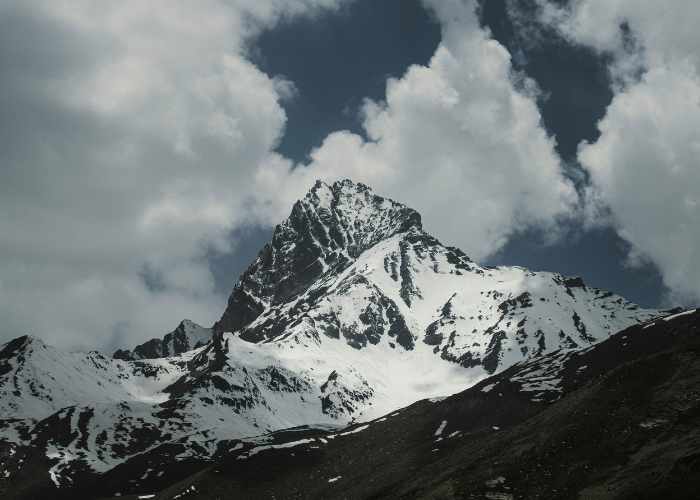
The Parang La Trek is a 13-day high-altitude journey that follows an ancient trade route from Spiti Valley to Ladakh. Beginning with a drive from Manali to Kibber, the trail crosses the Parang La Pass (5,600 m) and winds through glaciers, gorges, and stark mountain terrain. Trekkers experience ever-changing landscapes, from barren valleys to snow-capped peaks, alongside the Parachu River. The route also offers cultural insights into “Little Tibet,” with monasteries and stories of old trade fairs adding depth to the adventure.
As the trek enters Ladakh, the scenery opens into the greener Changthang plateau, home to the nomadic Changpa herders and their unique way of life. The highlight is the arrival at Tso Moriri Lake, a turquoise expanse framed by snow-clad peaks, and the nearby Korzok Monastery. Each day combines long, rewarding hikes with striking Himalayan views and glimpses of wildlife. Supported by quality tents, meals, and guides, the trek offers both challenge and comfort for seasoned adventurers.
Manali
Manali - Kibber by car
KIBBER – THALTAK (4560 m) ~ 5-6 Hrs.
Descending through the gorge and arriving at the last village of the trek, Tumlay, at a distance of around 500 meters, one can see the Parang–La and the snow-capped mountains all around. This was once an ancient trade route between Spiti and Tibet. People also call Spiti Little Tibet; all the monasteries in Spiti bear the influence of Tibetan architecture. In the past, merchants from Tibet would participate in the trade fair held at La–Darcha in Kaza. They brought pashmina, silver and other commodities. The fair continues to be held in August and brings together local foods, artisans, and traditional displays of weaponry, dance, and other art forms.
THALTAK – BASE OF PARANG LA (4900 m) ~ 6 Hrs.
The Parang La trail is a hiker’s dream. The route from Parachu valley leads to the Rupshu’s high plains and further to the famous salt lake of Tso Moriri and the trail to Hanle and Tashigang. Today’s walk is a steep descent through the Parilugui gorge. The majestic Parilugui Summit stands erect towards the south of Parang La. One can occasionally catch glimpses of Himalayan wildlife comprising of Bhral, Marmot and Ibex. After an hour of descent and three hours of ascent, you reach the campsite, set amidst a stunning lunar-like landscape.
BASE – LARGYUP (4930 m) OVER PARANG LA (5600 m) ~ (7 – 8 Hrs.)
Here you will enjoy a panorama of the Himalayas on the right side of the pass. On one side of Largyup is a glacier across the mountain face, whereas the other side is dry. We descend 4 kilometres down the glacier from which the Parachu River originates.
LARGYUP – RACHU LAMO (4580 m) ~ 5 hrs.
An easy and enjoyable walk with two to three stream crossings. Here, the topography is different on both sides of the trail: on the right, you can find high snow-capped mountains, whereas on the left is a dry landscape along with the Parachu River snakes along to the Tibet frontier near Chumar village before reentering Spiti and joining the Spiti River at Sumdo.
RACHU LAMO – NORBU SUMDO (4300 m) ~ 4-5 Hrs.
A pleasant valley walk beside the Parachu River. Campsite by the river.
NORBU SUMDO – SOUTH OF TSOMORIRI (4450 m) ~ 5 Hrs.
We begin the morning with a river crossing followed by a walk through the Parachu valley. The valley suddenly opens up into the greener Changthang valley, the high northern steppes inhabited by the Changpa pastoral community.
The Changpa have retained their nomadic glory despite the harsh weather and changes coming to the Himalayan region. They live in the higher regions of Changthang at heights above 4.500 mts. Their means of livelihood depends upon their herds of yak, sheep, goats and horses with which they migrate from one pastoral land to another. Within Changthang, they can be spotted by their Ribose (black Yak hair tents). Changpa are warm-hearted people, devoted to their families and flocks. Their tents are adequately furnished with sheepskin mats and their day – to –day provisions stored in goatskin bags and goat hair sacks. They prefer to sleep beside their flock to guard them from predators.
The Changpa are primarily meat eaters and relish yak meat most. They show surprise when they see someone eating vegetables. They are very fond of tsampa (roasted barley flour) and also take salted butter tea.Their traditional clothing is colourful, prepared from cloth woven by them. Both men and women wear their long hair in braids. They treat all types of ailments with their own herbal medicines and call on an Amchi (Tibetan doctor) only in case of serious trouble.
KARZOK VILLAGE BY TSO MORIRI (4,250 m) ~ 6Hrs.
Today we walk along Tso Moriri, the largest lake in the Rupshu district. On its western shore stands Korzok monastery. The present building was erected around 1850, but the origin of the shrine goes back to the Mon and Dart times, possibly before the 9th century.
KARZOK – LEH (7 hours drive)
Rest in Leh
Flight out of Leh
Note: It is also possible that a route change may become necessary due to weather, inaccessibility through the mountain passes due to heavy snow, the condition of the trail, and the physical fitness of the clients.
What To Bring For The Trek
- Warm internal clothing (woollen and fleece, thermals)
- Waterproof and windproof clothing
- Comfortable hiking boots with good resistance against the snow and water
- Haversack
- Sandals (for river crossings)
- Woollen/tennis socks
- Gloves
- Cap and Beanie
- Sunglasses
- Sunscreen lotion
- Water bottle
- Torch and batteries,
- Chlorine pills (OPTIONAL: mountain stream water is very clean and pure and we do provide boiled water during the trek)
Climate
Daytime temperatures in the sun are pleasant but often windy. At night, and during rain or snow (especially in September and October), the temperature can drop sharply, sometimes below zero, so it’s important to be well-prepared with the recommended clothing and gear.
Logistics Provided During The Trek
- Accommodation in a two-person tent (high-altitude alpine tents of good quality)
- Heavy foam pad mattresses
- Sleeping bags
- Freshly cooked meals
- Services of an experienced guide and cook
- Utensils and crockery
- Kitchen tent
- Toilet tent, ponies or porters
- First aid kit
- Transportation during the trek

We’re an ethical eco-travel agency led by industry veterans, offering tailored Trans-Himalayan journeys.
Further Links
Get In Touch
- 163/1, Palm Meadows, Ramagondanahalli, Whitefield, Bengaluru 560066
- +91 98450 28448
- support@treksntrails.in